Discover how SeekOps designs intelligent drone flight paths and uses high-resolution imagery, orthomosaics, 3D models, and flux planes to assist in accurate, efficient methane emissions monitoring in any environment.
Read time: 5 minutes
Optimized Routes for Emissions Detection
Before we begin a project, we program detailed flight paths tailored to each site’s unique conditions. Every route is designed with two key priorities: maximizing methane plume coverage and ensuring operational safety.
Plans are built before our teams even arrive on site, using forecasted wind data to anticipate plume behavior and shape efficient flight patterns. If conditions shift, such as a sudden wind change, our skilled operators can generate new routes instantly, ensuring no data gaps and no wasted flight time.
This approach isn’t just about flying drones, it’s about flying the right path for the environment, infrastructure, and emissions target.
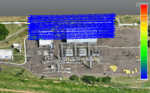
Flux Planes: Mapping Plumes in Motion
At the heart of SeekOps’ quantification strategy is the use of flux planes, or vertical slices of space where methane concentration and wind data are measured simultaneously. As the drone flies back and forth across these planes, it builds a precise, three-dimensional profile of the methane plume in real time.
Flux planes allow us to quantify the total mass flow rate of methane passing through the plane, capture plume shape, density, and movement under actual site conditions, and adapt flight patterns mid-mission if the plume shifts due to wind changes.
By integrating flux planes into our flight paths, we turn aerial surveys into dynamic, high-fidelity measurements. It’s not just about detecting a leak, it’s about understanding exactly how much methane is moving, where it’s going, and what’s driving it.

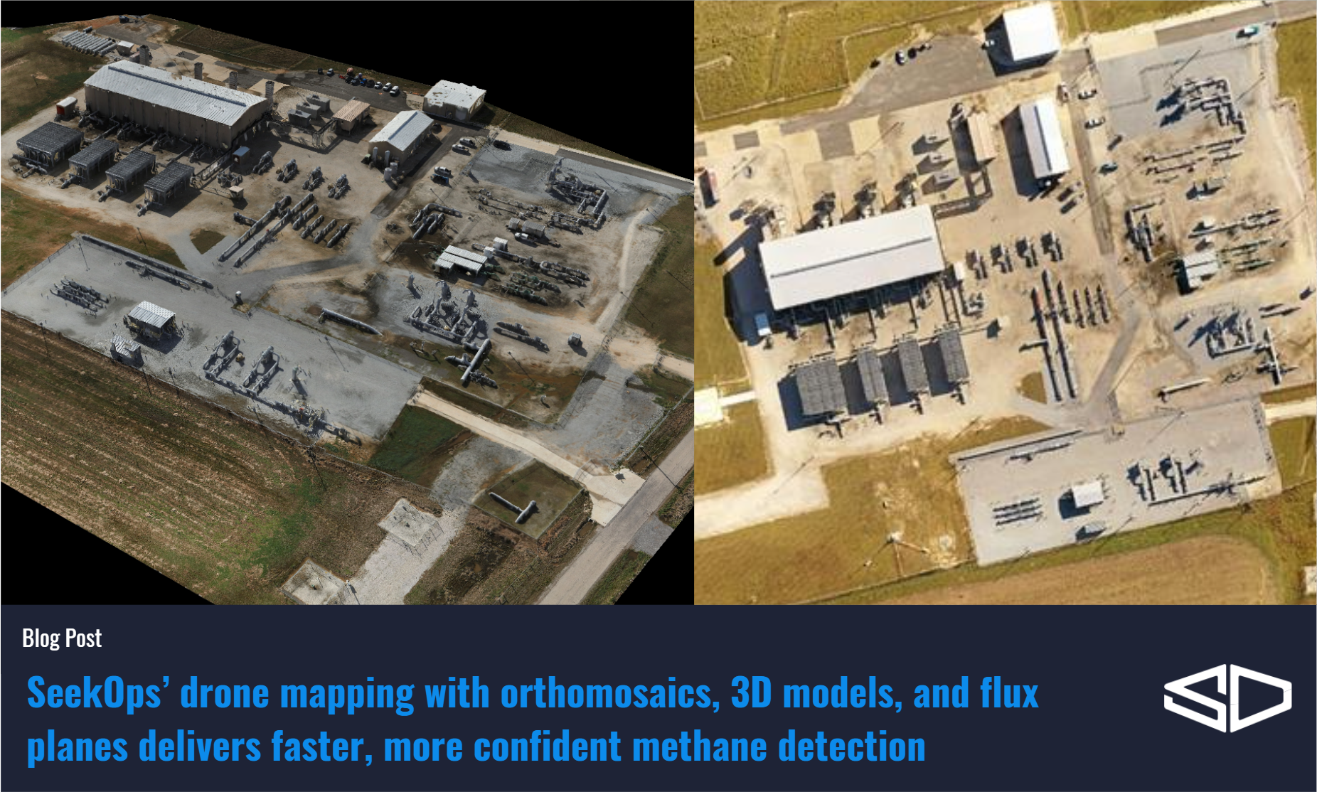
A Bird’s-Eye View
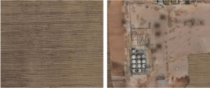
To support our detailed analysis and data presentation, we can capture high-resolution, up-to-date imagery that shows the site exactly as it is, whether that means newly installed process equipment, scaffolding, or temporary construction zones. This visual intelligence is far more reliable than outdated satellite images, ensuring that we have context that matches the reality in the field.
Orthomosaics: Detailed Maps for Analysis
While flight paths are the backbone of our approach, orthomosaic maps add a layer of precision. These are high-resolution, georeferenced images stitched together from hundreds of individual aerial photographs.
For SeekOps, orthomosaics are:
Operationally current – showing the exact site layout on the day of the survey, including temporary installations, scaffolding, and safety barriers.
Analysis-ready – allowing our findings to be overlaid and interpreted directly within operational workflows
Reusable – serving as a reference for future surveys and change detection over time.
Orthomosaics are especially valuable for sites where outdated satellite imagery might show an empty lot but are actually a busy industrial environment.
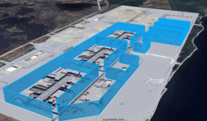
3D Models: Adding Height to the Equation
In certain environments, such as offshore platforms, urban facilities, or sites with stacked infrastructure, 2D maps alone aren’t enough. That’s where 3D models come in.
Using photogrammetry from multiple angles, our drones can generate 3D representations of the site. This allows us to:
Understand equipment height and elevation changes for better plume modeling.
Accurately attribute emissions to the proper equipment groups.
Depict where the methane plumes are coming from in our reports.
3D models are particularly effective in tight or congested areas where methane plumes may behave unpredictably due to airflow restrictions.
Efficiency in the Air
The drones fly these custom routes autonomously, but each one is backed by human expertise. Skilled operators know how to integrate wind data, site hazards, and plume modeling into the plan, balancing complete coverage with the shortest possible airtime.
This efficiency matters. It reduces battery use, minimizes exposure to harsh environments, and ensures that methane detection happens at the optimal time and place.
Consistency You Can Compare
Once a flight path has been proven effective, we save it for future surveys. This enables exact repeatability, allowing operators to track changes in emissions before and after maintenance, compare seasonal conditions, or analyze the same equipment over time. Consistency like this builds robust data sets and high-confidence trends, something extremely difficult to achieve with handheld tools or one-off aerial flyovers.
From Planning to Action
By pairing accurate site imagery, orthomosaics, and 3D modeling with intelligent flight path design, SeekOps ensures that every drone mission collects the most useful data in the least amount of time.
When combined with our real-time monitoring capabilities, this approach transforms aerial surveys into actionable intelligence, helping operators identify, quantify, and act on emissions faster than ever.
Stay tuned for the next post in our series: “FASTR Insights – Real-Time Awareness from Sky to Screen”
Want to see what methane emissions your site is emitting?
Schedule a survey or Talk to an expert
References
Corbett, A., & Smith, B. (2022). Study of a Miniature TDLAS System Onboard Two Unmanned Aircraft to Independently Quantify Methane Emissions from Oil and Gas Production Assets and Other Industrial Emitters. Atmosphere, 13(5), 804. https://doi.org/10.3390/atmos13050804
Smith, B. J., Buckingham, S., Touzel, D., et al. (2021). Development of Methods for Top-Down Methane Emission Measurements of Oil and Gas Facilities in an Offshore Environment Using a Miniature Methane Spectrometer and Long-Endurance UAS. SPE Annual Technical Conference and Exhibition, Dubai, UAE. https://doi.org/10.2118/206181-MS
Tavner, C. A., Touzel, D. F., & Smith, B. J. (2021). Application of Long-Endurance UAS for Top-Down Methane Emission Measurements of Oil and Gas Facilities in an Offshore Environment. SPE Offshore Europe Conference and Exhibition, Virtual. https://doi.org/10.2118/205467-MS
Hossian, R. I., et al. (2024). A Controlled Release Experiment for Investigating Methane Measurement Performance at Landfills. Environmental Research and Education Foundation (EREF). https://erefdn.org/eref-funded-study-highlights-advances-in-measuring-landfill-methane-emissions
Ravikumar, A. P., Sreedhara, S., Wang, J., et al. (2019). Single-blind inter-comparison of methane detection technologies – results from the Stanford/EDF Mobile Monitoring Challenge. Elementa: Science of the Anthropocene, 7(1), 37. https://doi.org/10.1525/elementa.373